History of the Manchester Ship Canal
Content provided by our archivist, Richard Andrews
Early History
Ideas and proposals to improve the navigation on the River Mersey and Irwell to Manchester were introduced as early as 1660 but no improvements were carried out before the first Act of 1721. As part of these early ideas a Ship Canal was mentioned in 1710 from Manchester to the sea, but it was another 100 years before the idea was more formally proposed.
Sir John Rennie produced a report in 1838 on a Ship Canal from Liverpool to Warrington, which could be extended to Manchester, followed by a proposal for two schemes in 1840 from H.R. Palmer and John H. Bateman.
But it was not until the 1870’s after difficult economic conditions and a period of time known as the “Long Depression”, that Manchester businessmen started to complain about the high cost of exporting goods via the Port of Liverpool. George Hick’s in a letter to the Manchester Guardian in 1876 suggested the rivers Mersey and Irwell should be converted to a Ship Canal, and in 1877 the Manchester Chamber of Commerce considered Hamilton Fulton’s scheme for an improved waterway from the sea.
Hamilton Fulton’s 1877 scheme proposed a tidal channel requiring a cut across the Liverpool estuary bar and a channel cut into the River Mersey bed to allow ships at high tide to reach Manchester, where a tidal basin would receive the ships.
Manchester businessmen voting in favour of a Ship Canal in 1879 and the publication of pamphlets in 1882 urging a tidal navigation to Manchester, all contributed to Daniel Adamson calling a meeting to discuss tidal navigation on 27th June 1882.
Early Years of the Ship Canal
On 27th September 1882 Edward Leader Williams who was overseeing the rebuilding of old navigation improvements the River Weaver Navigation to accommodate coasters of up to 1000 tons, presented a scheme for a large Ship Canal with locks.
The First Act of Parliament submitted in March 1883 included a proposal drawn up by Mr. Boddington for a tidal canal cut across from Astmoor Salt Marsh to Warrington, before a tidal lock and two further sets of locks to reach new docks to be built in Salford. The Act was rejected on 9th August 1883.
The Second Act of Parliament submitted in May 1884 included a low water canal from Garston to Runcorn similar to the Fulton 1877 scheme, a tidal lock and sluices at Astmoor Salt Marsh and a further four sets of locks to reach new docks at Salford. This Act was rejected on 1st August 1884.
The Third Act of Parliament submitted in July 1885 which was successful included the shoreline channel which we know today from Eastham (Tidal locks and sluices) to Runcorn before becoming a new canal cut to Manchester with locks at Latchford, Irlam, Barton and Salford.
It took a further two years to resolve all the disputes and raise the necessary capital before Lord Egerton the Chairman of the Manchester Ship Canal Company on 11th November 1887 cut the first sod on the site of Eastham locks.
The Construction Years
The route was divided into eight sections:
- 1. Eastham.
- 2. Runcorn.
- 3. Norton.
- 4. Warrington.
- 5. Latchford.
- 6. Irlam.
- 7. Barton.
- 8. Manchester.
The River Mersey and Irwell Navigation, which would be destroyed by the construction of the new Ship Canal, was used along with hundreds of miles of temporary railway lines laid along the route of the Ship Canal, to set up temporary offices, workshops, and deposit thousands of tons of materials required to construct the Ship Canal.
By the end of 1887 physical work had started at Eastham, Warrington, Warburton and Salford.
During 1888, miles of timber posts were driven into the soft peaty soil along the shoreline from Eastham to Runcorn where a sea wall (or gantry) would be built on the north side of the river for the Ship Canal wall. Where the route allowed, natural embankments were extended and strengthen on the river estuary. Spoil from the excavations was deposited in these areas. Some grew to a significant height and became local landmarks themselves (Mount Manisty).
The timber piles then allowed a temporary timber platform to be built to allow coffer dams to be constructed so that the excavations down to rock or hard gravel could be made to allow the sea walls to be constructed.
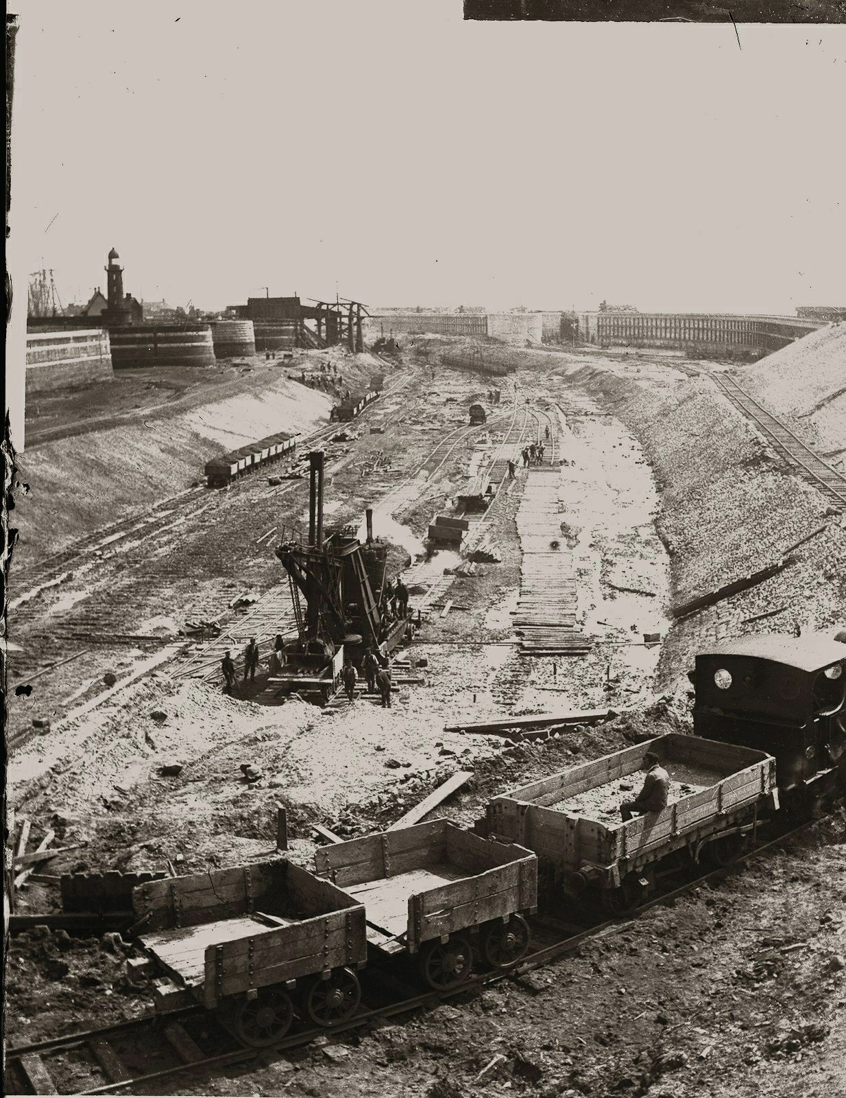
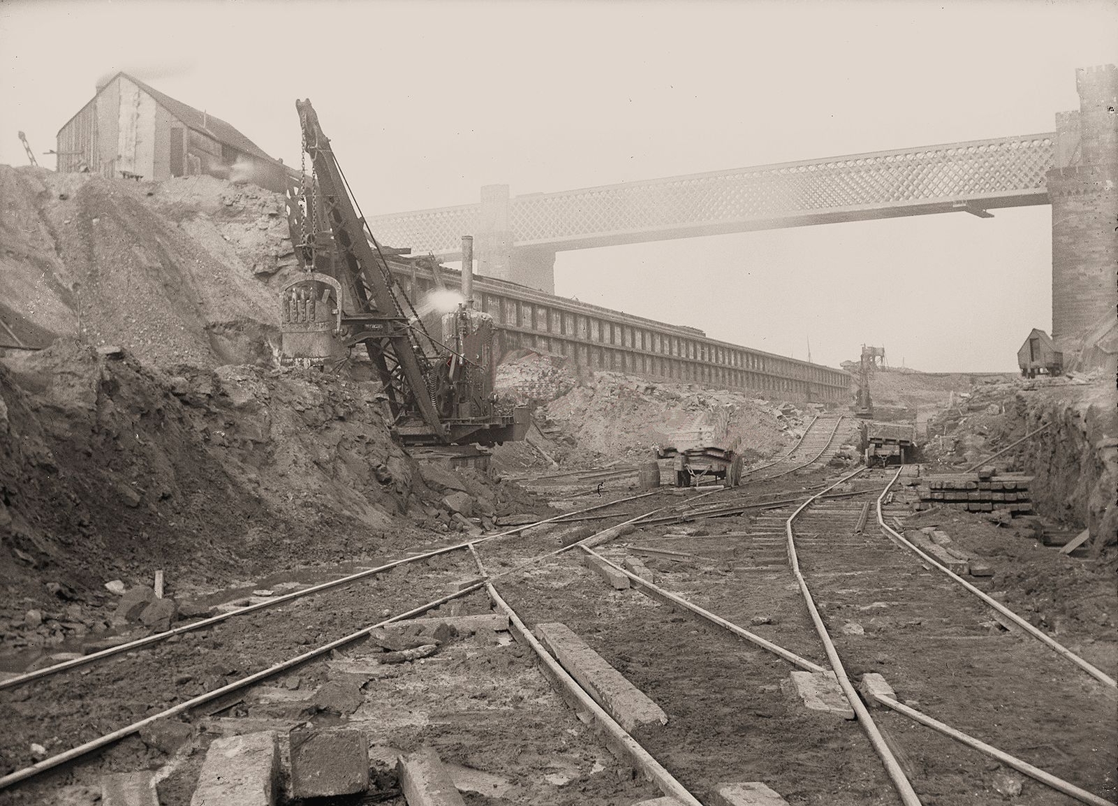
The excavation of the canal itself was dug by thousands of navvies working long hours, but assisted by steam excavators where the ground allowed, or dredgers at high water across the marshland.
In some sections it was possible to dig a trench several miles long and then flood the length behind temporary dams and allow dredgers built on the dry bed to float up and commence dredging the canal to its designed depth.
Where rock was encountered explosives and navvies dug the canal down to the required depth. An explosive store was built on Frodsham marshes away from towns and villages along the route.
Delays were common, with inclement weather causing flooding and storm conditions on the River Mersey breeching the partly built sea walls and embankments. In 1891 an industrial dispute over wages and concerns raised by the railway company at Runcorn Railway Bridge delayed completion of the Runcorn section.
The Runcorn section could not commence until after the Ship Canal was completed across the mouth of the River Weaver and the Weston Marsh lock built into the River Weaver Canal was open. To achieve this a dam was built below Runcorn Docks at the Foreshore Pumping Engine Station (see map below).
The Ship Canal opened to the mouth of the River Weaver and the Weston Marsh lock on 28th September 1891, allowing work to start on the Runcorn section.
Construction at Weston Point
With the pending closure of the Weston Point and the Runcorn Docks, a temporary port was built on Frodsham Marshes. On 22nd July 1892 the now named Salt Port was opened allowing large ocean-going vessels to enter the new Ship Canal at Eastham and sail up to Salt Port, to transfer their goods to smaller vessels to use the new Weston Marsh lock. Goods could then be shipped via the River Weaver Canal to either Weston Point or Runcorn and onto the Bridgewater Canal, or up the River Weaver to Northwich and Winsford.
Excavating the 'Runcorn Bend'
The construction works past the Runcorn Docks, around the Runcorn Bend and to the Old Quay took nearly two years to complete, with delays caused by industrial action and the Runcorn Railway Bridge cutting. Further difficulties in this section included three sets of river locks to be built to serve the Weston Point docks, Runcorn docks and the Bridgewater Canal and the Old Quay at Runcorn. A near disaster occurred as the Old Quay locks were nearing completion when a storm flood on the River Mersey caused the inner lock wall to crack and move. The whole structure had to rapidly demolished, and it was found that an unknown sand layer in the compacted gravel bed had allowed water to enter and caused settlement of the lock foundations.
The Runcorn section was finally completed in 1893 with water being admitted into the finished section in June and July of that year.
The whole canal from Eastham to Manchester was filled by 23rd November 1893 and a month later when all the temporary bridge crossings and structures had been removed, and the canal dredged to it’s final working depth, the new Ship Canal opened for traffic to Manchester on 1st January 1894.
Improvements
An Act of Parliament dated 15th August 1904 increased the depth of the Ship Canal from 26 to 28 feet.
In 1911 the Runcorn Bend was improved by extending the bottom width from 120 feet to 150 feet to allow large Australian steamers to reach Manchester. There is a suggestion in the article that the steamers could stop at Runcorn to collect and/or discharge passengers.
In 1922 the Stanlow Island oil taker berth was opened.
Return to Main MenuBibliography
- Cyril J. Wood, MSC The Big Ditch (2005)
- Ted Gray, A Hundred Years of the Manchester Ship Canal (1993)
- Derek A. Clulow, No Tides to Stem (1995)
- Wikipedia, Manchester Ship Canal